
-
Research Presented at Multiple NASA MeetingsWednesday July 5, 2023
-
Research Presented at 9th ABoVE Science Meeting (ASTM-9)Held in San Diego, California, January 23-26, 2023Monday July 3, 2023
-
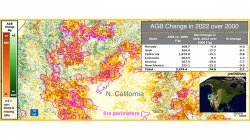
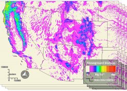
Tracking forest biomass and disturbance with NASA's MISRDr. Mark Chopping, Professor, Earth and Environmental Studies, and colleagues have published NASA-funded research to map aboveground biomass and disturbance in southwestern forests using multi-angle imaging. Monday April 11, 2022
-
Lab welcomes PhD student Darko RadakovicMonday October 19, 2020

-
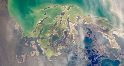
Satellite Eye on EarthGlaciers melting, dust storms raging and typhoons blowing - all captured by NASA's Earth Observatory satellites each monthMonday June 13, 2016
-
NASA Earth ObservatoryImages and information from the NASA Earth Observatory Monday June 13, 2016
-
News and Resources in Remote SensingFriday October 16, 2015
-
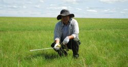
Remote Sensing Lab Research Update – Bao GangVariability of Vegetation Net Primary Productivity on the Mongolian Plateau 1982 - 2010 and its Response to Climate ChangeFriday October 16, 2015
-
Remote Sensing Lab Research Update – Phillip GomezA High-Resolution Delineation of the Circumpolar Taiga-Tundra EcotoneFriday October 16, 2015
-
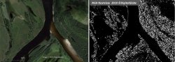
Our proposal to NASA's ABoVE program has been selected!Changes in Shrub Abundance in Arctic Tundra from the Satellite High Resolution Record for the Arctic-Boreal Vulnerability Experiment and Impacts on Albedo Friday August 28, 2015
遥感实验室位于地球与环境研究系(EAES)。 Research activities in the lab are sponsored by NASA. 目前的项目是利用美国宇航局地球观测系统卫星仪器的数据来绘制美国西南部沙漠草原和北极苔原的森林和灌木地图。
Previous projects sought to exploit data from the Compact High Resolution Imaging Spectrometer (CHRIS) flown on the Proba satellite (sponsored by the European Space Agency).
A research focus is the use of data from the unique NASA/JPL Multiangle Imaging Spectro-Radiometer (MISR), including cutting-edge work on mapping canopy height as well as crown cover; and mapping woody plant cover and community type in desert grasslands and Arctic tundra.
The Lab’s members have included faculty, post-doctoral research associates, and graduate and undergraduate students.
Relevant courses include
- EAES 311 Fundamentals of Remote Sensing of the Environment (undergraduate)
- EAES 511 Fundamentals of Remote Sensing of the Environment (graduate)
- EAES 611 Advanced Environmental Remote Sensing and Image Processing (graduate)
- EAES 210 Introduction to GIS and Remote Sensing (2 hours lecture, 2 hours lab )
- EAES 310 Geographic Information Systems (GIS) (3 hours lab)
- EAES 410 Advanced Topics in GIScience (3 hours lecture)
- EAES 610 Spatial Analysis
- EAES 710 Advanced Geographic Information Systems
- Graduate Certificate Program in Geographic Information Science
- Independent Study at various levels.
Research
- Changes in Shrub Abundance and Albedo in Arctic Tundra…
- Changes in Shrub Abundance in Arctic Tundra…
- Forest and shrub mapping with NASA EOS multiangle remote sensing data (MISR, MODIS)…
Click to zoom:
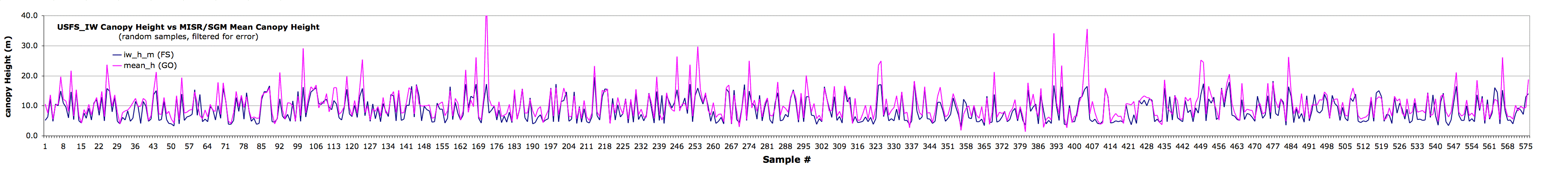
Purple line: MISR/SGM forest canopy height (m)
Blue line: US Forest Service Canopy Height (m)
random samples, screened for topographic shading
It’s important to note that the Forest Service and MISR/GO maps were made using completely different methods. The MISR/GO estimates of fractional woody plant cover and canopy height are not calibrated or scaled, relying only on the geometric-optical model adjusted against MISR data.
- Mapping Carbon Pools in Desert Grasslands using EOS Multi-Angle Data
- Physical Structure of Desert Grasslands using Multiple View Angle Data from CHRIS
- Dramatic Changes in Urban Area in Inner Mongolia:
- Multi-angle remote sensing from the air and associated field data
- BRDF Applications in Semiarid Grassland Monitoring with the AVHRRs
Support
- NASA Earth Observing System (EOS)
- NASA Terrestrial Ecology Program
- NASA LCLUC program
- European Space Agency CHRIS-PROBA Mission